I’ve gone through a few areas and unmasked the water ways to make them a bit more immersive.
It’s funny, because doing this doesn’t really add any size to the scenery, as the imagery is already there, X-Plane is just being told to cover it over with deep blue sea.
Here’s a look at some of the additions I’ve made.

This is the mouth of the Wairoa River, which might seem pretty random, except that in the distance is straight in to Ardmore airfield.

Now at the other end of Ardmore, we have the inlet, just south of Auckland Intl.

Still in the area, we have Mangere Inlet, and Auckland Intl is the distance. I’ve also done Tamaki Esturary and along Tamaki Drive to the central city of Auckland.

I’ve photoshopped out the Auckland Harbour Bridge and Upper Harbour Bridge, so there won’t be a weird bridge painted on the ground.

Hobsonville has been updated to about 2017, with new suburbs constructed and the North Western Ring Route motorway is now finally complete!

Okay, one last look at Auckland from another direction.
But who wouldn’t want to fly to Dunedin with a Harbour like that?

I’ve also updated Christchurch Airport, so that it is more green and up to date. I’ve also removed a lot of bad imagery from the city.

Other than that, I’ve been fixing missing scenery and trying to get rid of blurry patches where there was nothing available.
Here’s a look at Mt Cook with a recent repair job complete. This was the worst part of the Southern Alps, with a giant cloud

Here’s what the area looks like in the source photo ArcGIS provides:

Oh, and I almost forgot. Here’s Whangarei before:

And Whangarei after:


Want a particular inlet to be unmasked? Let me know in the comments below!
Categories: Flight Simulation
 On a layOver
 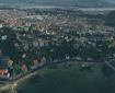 Freeware – OSM Overlay for New Zealand and the Chatham Islands
  The (Over)lay of the land
  Lyndiman’s Ortho UHD Mesh Release
Nelson (boulder bank etc), general Tasman Bay area (shallow waters everywhere) and perhaps Banks Peninsula spring to mind…
Great suggestion around Nelson, especially because it’s right off the end of the runway.
Are those bridges around Waitemata intact? They look slightly gappy from the shot
The gaps are actually real. The causeway ends and a couple of bridges are there. This allows water to flow into the rivers. Millions was just spent doubling the width of those motorways too.
I agree that Tasman would be great.
Yes. All done.
Fantastic work, but you might also like to add a feathered edge to coast lines so that the deep blue gradually fades into the orthophotos 🙂 Looking forward to flying here again soon.
Yes, 100 metres of feathering doesn’t seem to cut it.
PS – Gisborne?
Yes
NIce work! Thank you for doing this!
Just north of Flat Point on North Island, there’s a rather obtrusive tile-edge colour mismatch, running inland from the coast. That might be a candidate to fix.
Oh yeah, that’s a big one! I don’t fly up that coast, so never noticed it.
There’s a very nice private strip at Flat Point, which some of us have been known to nip into, IRL…
And another airstrip at Porangahau, further up the coast, which has to be one of the finest beaches in Hawke’s Bay, if not the entire island. Worth a look.
Another candidate for fixing the water masks: the small islands in Kawau Bay, near Warkworth
Tauranga Harbour would be a must 🙂